Wind chill advisory January 24-25
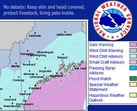
The National Weather Service has issued a wind chill advisory through noon Friday, Jan. 25, for the entire southern and eastern half of the state.
Dangerous cold will make it hazardous to go outside without proper protection as temperatures will be minus 8 t0 14 above zero. Adding winds of 6 to 17 mph, and the wind chill values will be as low as minus 23 Thursday night through Friday morning.
A wind chill advisory means the combination of very cold air and winds will create dangerously low wind chill values, which will result in frost bite or lead to hypothermia if precautions are not taken.
The NWS advises that if people need to go outside they dress in layers and keep all skin and heads covered. In addition, people are urged to protect livestock from the cold and bring pets inside.
The January 24-28 forecast follows:
Thursday night, Jan. 24: Mostly clear, with a low around 2 F. Wind chill values as low as minus 14. West wind 7 to 17 mph, with gusts as high as 34 mph.
Friday, Jan. 25: Mostly sunny, with a high near 13 F. Wind chill values as low as minus 18. West wind 6 to 9 mph.
Friday night: A slight chance of snow between 1 and 2 a.m. Cloudy, with a low around 7 F. Wind chill values as low as minus 2. Light and variable wind becoming north around 6 mph after midnight. Chance of precipitation is 20 percent.
Saturday, Jan. 26: A slight chance of snow between 8 and 10 a.m. Cloudy, with a high near 19 F. Wind chill values as low as minus 6. Northwest wind 7 to 10 mph. Chance of precipitation is 20 percent.
Saturday night: Partly cloudy, with a low around 6 F. Northwest wind around 9 mph.
Sunday, Jan. 27: Sunny, with a high near 20 F.
Sunday night: Mostly clear, with a low around 4 F.
Monday, Jan. 28: Sunny, with a high near 26 F.
Event Date
Address
United States