‘Points of Interest’ in Edgecomb
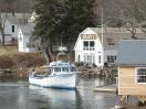
 The blockhouse at Fort Edgecomb. PHIL DI VECE/Wiscasset Newspaper
 The author and Bo.
The blockhouse at Fort Edgecomb. PHIL DI VECE/Wiscasset Newspaper
The author and Bo.
The author and Bo.
The blockhouse at Fort Edgecomb. PHIL DI VECE/Wiscasset Newspaper
The author and Bo.
The other day, I rediscovered something I’d put away and forgotten about – a map of Edgecomb featuring “16 Points of Interest” to visit. I had meant to write something about this last year when the town was celebrating its 250th anniversary, but never got around to it.
I’ve always been fascinated with maps and have a modest collection of them.This particular one isn’t very old and looks to me like it was made in the 1960s, or 70s. I think it might have been something the late John Chase put together.John certainly knew a great deal about Edgecomb’s early history having lived much of his long life on Cross Point Road. The home he shared with his wife Audrey was about a mile south on Eddy Road. For years, John was postmaster of the North Edgecomb Post Office, back when the mail was sorted in the little brick building off Atlantic Highway. After John retired, he wrote a weekly column that appeared in both the Boothbay Register and Wiscasset Newspaper when they were separate publications.
It was John’s sister, Katherine Chase Owen, who in the mid-1980s wrote a history of Edgecomb.Mrs. Owen compiled a great deal of her information with John’s help of course, and from others, including Lawrence I. Davis who lived on Davis Island. Mr. Davis spent most of his working career as Edgecomb’s town clerk and could trace his ancestry back to the 1770s. He was a direct descendent of Moses Davis, one of the town’s earliest settlers and community leaders.Moses Davis in fact took part in the convention when Massachusetts ratified the new Constitution of the United States.The original Davis homestead is still standing on the east side of the island, not far from the ancient Davis Cemetery where Moses Davis rests in peace.
Well, getting back to that map, along with these so-called “points of interest,” it shows the major roads and bodies of water. Edgecomb is bordered on its western side by the Sheepscot River, and the Damariscotta River on the eastern side. The map also shows Parson’s Creek, which runs roughly a mile northeast from a place called Ovens Mouth, the upper part of the Cross River that forks off from the Sheepscot near High Head on Cross Point. Another of the town’s natural features shown is Lily Pond, a good-sized freshwater lake.Although it can’t readily be seen from Route 27, Lily Pond is roughly southwest within walking distance of the town hall.
Now to these so-called “points of interest.” As you might surmise, Fort Edgecomb State Park off the aptly named Fort Road is first on the list. The historic blockhouse built between 1808 and 1809 for defense of the harbor is closed now for the winter, although the grounds are open year-round. The park includes a number of informative kiosks and offers picture-worthy views of the river.
Next up, the Queen Marie Antoinette House. Heading south on Eddy Road, the Colonial-style house (privately owned) with its distinctive center chimney sits on a small rise overlooking the Sheepscot River.The story of the Marie Antoinette House has been told many, many times.As the legend goes, the house was to serve as a safe haven for the Queen of France who had been imprisoned during the French Revolution.Unfortunately, for Marie Antoinette, the attempt to rescue her failed and she was executed in 1793. The home built in the mid-1770s was originally located on Westport Island.The building was ferried across the river to its present location in the 1830s.
The points of interest include two churches, although only one, Edgecomb Community Church, aka Edgecomb Congregational Church, remains active. The other one, the former Baptist Church, was on Old County Road, and is now home to a wood-working business. Edgecomb Community Church with its landmark white steeple and bell tower is near the junction of Eddy and Cross Point roads. Also shown on the map is the Edgecomb Town Hall built in 1794 and still used for town meetings and town business. It’s on Route 27 alongside the town cemetery.
Edgecomb residents have long supported public education.In the late 1880s, the community had seven public schoolhouses. Some of these buildings have survived and are now private homes. Only one is shown on the map, the wood-framed Eddy School next door to the congregational church on Cross Point Road.The building greatly remodeled over the years is now home to Edgecomb Green, an assisted living community and part of the Eldercare Network.There are many adults living in the area who attended the old Eddy School.
The map marks the location of William’s Hill, also known as Mount Edgecombe.It’s in East Edgecomb between the McKay and River roads. The hill – the highest point of land in town – has an elevation of 321 feet. Because the trees have grown up all around it, its rise is scarcely noticeable.I’ve read, a century ago when this area was clear of timber, you could see all the way to Boothbay Harbor and the ocean from the summit of William’s Hill.Not shown on the map is nearby Mount Hunger off Old County Road and now a part of the 766-acreCharles and Constance Schmid Preserve, which didn’t exist when this map was drawn. The map does show the approximate location of the Old Cattle Pound, also now a part of Schmidt Preserve.As I remember it, this is a fairly large area surrounded by stone walls.Long ago, when this was cleared pasture land, livestock were herded into the pound for safekeeping.
Another point of interest that appears is the historic Stephen Parsons house (privately owned) that was fully restored fairly recently. Built in 1806 and fronting Parsons Creek, the house and adjacent barn are at the end of Nichols Road.More information about Stephen Parsons and his many contributions to the community and the house's unique features appears on the website of Edgecomb Historical Society.When I first knew it, this was the home of Doctor Arthur Nichols, his wife Madene and their family.
Cod Cove, “a place renowned for birdwatching,” is listed as a point of interest. It’s on the north side of Eddy Road on Davis Island. Alongside the dike on Eddy Road is a place to park your vehicle where you can admire the view of the cove.
There’s more, but we’ll conclude with the former Mica Mine also within the boundaries of Schmidt Preserve. The one-time open pit mine is accessible from either the orange-blazed "Mica Trail” or the “River Link Trail.”In the 1880s, feldspar and mica were dug here and shipped from Poole's Landing in east Edgecomb for processing at a crushing mill on the Cathance River in Topsham. White feldspar was the more marketable of the ores as it was used as an ingredient to make fine dinner china. Mica (isinglass) was mostly used to make heat-resistant windows for wood and coal stoves.
Phil Di Vece earned a B.A. in journalism studies from Colorado State University and an M.A. in journalism at University of South Florida. He is the author of three Wiscasset books and is a frequent news contributor to the Boothbay Register/Wiscasset Newspaper. He resides in Wiscasset.